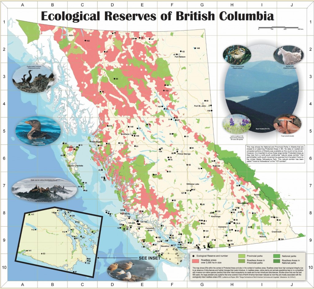
Map of Ecological Reserves

Below is a map of the ecological reserves of BC. Each reserve is numbered from 1 to 158. Refer to the table below the map for the names of each reserve.

You can click on the map below, and then again, to get a larger image on which you can zoom and pan.

 The total area of protected lands (provincial and Federal) in BC is 13,521,180 ha.
Total Area of ERs is 112,543 ha. which represents only 0.8% of the protected area system.

List of ERs by number:

ER#

  Ecological Reserve Name

1

* Cleland Island

2

East Redonda Island

3

Soap Lake

4

Lasqueti Island

5

Lily Pad Lake

6

Buck Hills Road

7

Trout Creek

8

Clayhurst

9

Tow Hill

10

Rose Spit

11

* Sartine Island

12

* Beresford Island

13

* Triangle Island (Anne Vallee)

14

* Solander Island

15

Saturna Island (to GINPR)

16

Mount Tuam

17

* Canoe Islets

18

* Rose Islets

19

Mount Sabine

20

Columbia Lake

21

Skagit River Forest

22

Ross Lake

23

* Moore/McKenney/Whitmore Islands

24

* Baeria Rocks

25

* Dewdney and Glide Islands

26

Ram Creek

27

Whipsaw Creek

28

Ambrose Lake

29

Tranquille

30

Vance Creek

31

Lew Creek

32

Evans Lake

33

Field’s Lease

34

Big White Mountain

35

Westwick Lake

36

Mackinnon Esker

37

Mount Maxwell

38

Takla Lake

39

Sunbeam Creek

40

Kingcome River/Atlatzi River

41

Tacheeda Lakes

42

* Mara Meadows

43

Mount Griffin

44

* East Copper/Jeffrey/Rankine Islands (to GHNPR)

45

Vladimir J. Krajina (Port Chanal)

46

Sikanni Chief River

47

Parker Lake

48

Bowen Island

49

Kingfisher Creek

50

Cecil Lake

51

Browne Lake

52

Drizzle Lake

53

Narcosli Lake

54

Nitinat Lake

55

Cardiff Mountain

56

Goosegrass Creek

57

Chickens Neck Mountain

58

Blue/Dease Rivers

59

Ningunsaw River

60

Drywilliam Lake

61

Upper Shuswap River

62

Fort Nelson River

63

Skeena River

64

Ilgachuz Range

65

Chasm

66

Ten Mile Point

67

Satellite Channel

68

Gladys Lake

69

Baynes Island

70

Mount Tinsdale

71

Blackwater Creek

72

Nechako River

73

Torkelsen Lake

74

Pacific Spirit /U.B.C. Endowment Lands

75

Clanninick Creek

76

Fraser River

77

Campbell Brown (Kalamalka Lake)

78

Meridian Road (Vanderhoof)

79

Chilako River

80

Smith River
https://ecoreserves.bc.ca/portfolio_item/156-Elphinstone additions-Proposed-er/

ER#

  Ecological Reserve Name

81

Morice River

82

Cinema Bog

83

San Juan Ridge

84

Aleza Lake

85

Patsuk Creek

86

Bednesti Lake

87

Heather Lake

88

Skwaha Lake

89

Skagit River Cottonwoods

90

Sutton Pass

91

Raspberry Harbour

92

Skihist

93

Lepas Bay

94

Oak Bay Islands

95

Anthony Island (to GHNPR)

96

Kerouard Islands (to GHNPR)

97

Race Rocks

98

Chilliwack River

99

Pitt Polder

100

Haynes’ Lease

101

Doc English Bluff

102

Charlie Cole Creek

103

Byers/Conroy/Harvey/Sinnett Islands

104

Gilnockie Creek

105

Megin River

106

Skagit River Rhododendrons

107

Chunamon Creek

108

Cougar Canyon

109

Checleset Bay

110

McQueen Creek

111

* Robson Bight (Michael Bigg)

112

Mount Tzuhalem

113

Honeymoon Bay

114

Williams Creek

115

Gingietl Creek

116

Katherine Tye (Vedder Crossing)

117

Haley Lake

118

Nimpkish River

119

Tahsish River

120

Duke of Edinburgh (Pine/Storm/Tree Islands)

121

Brackman Island (to GINPR)

122

Tsitika Mountain

123

Mount Derby

124

Tsitika River

125

Mount Elliott

126

Claud Elliott Creek

127

Big Creek

128

Galiano Island

129

Klaskish River

130

Mahoney Lake

131

Stoyoma Creek

132

Trial Islands

133

Gamble Creek

134

Ellis Island

135

Bowser

136

Comox Lake Bluffs

137

Hudson Rocks

138

Klanawa River

139

Yellowpoint Bog

140

Misty Lake

141

San Juan River Estuary

142

Woodley Range

143

Liumchem

144

Yale Garry Oak

145

Burnt Cabin Bog

146

Catherine Creek

147

Grayling River Hot Springs

148

* Kotcho Lake

149

Portage Brule Rapids

150

Rolla Canyon

151

Ballingall Islets

152

Ospika Cones

153

Francis Point

154

Det San

155

Pink Mountain (Proposed ER)

156

Elphinstone Additions (Proposed ER)

157

Eosine Fossil Sites (Proposed ERs)

158

 Koksilah/Eagle Heights (Proposed ER)

159

Fording River Grasslands (Proposed ERs)

General Posts on Marine Reserves
General Posts on Terrestrial Ecological Reserves
General Posts on Fresh water/Aquatic Ecological Reserves

(GINPR)  – Gulf Islands National Park Reserve

(GHNPR) – Gwaii Haanas National Park Reserve

 *  These ecological reserves are closed to the public due to the sensitive nature of these areas. The closure at Robson Bight (Michael Bigg) Ecological Reserve covers the land component of the ecological reserve only.

The total area of protected lands (provincial and federal) in BC is 13,521,180 ha.

Total area of ERs is 112,543 ha. which represents only 0.8% of the protected areas system.